
The Outback's Heart

The Gary Junction Road has been described as one of the best drives in outback Australia, with incredibly beautiful desert scenery, Indigenous art and culture, and bush camping under innumerable stars. More picturesque than the Tanami Road, more interesting than the Great Central Road, and way easier than the Anne Beadell Track, you’ll be hard-pressed to find a better trans-continental adventure than ‘The Gary.’
Although it follows the original track carved out by Len Beadell’s crew in the 1960s, it has been re-graded and maintained as a wide, relatively smooth highway across the Great Sandy Desert, providing an essential link between Alice Springs in the Northern Territory and Marble Bar in Western Australia, sustaining several remote Indigenous communities along the way.
THE GREAT SANDY DESERT
At 284,993sq km, the Great Sandy is the second largest desert in Australia. It straddles a vast region bounded by the Pilbara and Kimberley in the north-west, the Gibson Desert to the south and the Tanami Desert to the east. The landscape is a flat sedimentary basin covered by sand plains and dunes of a deep coral pink, shaped by the prevailing westerlies into rows of parallel ridges up to one hundred kilometres long.
The dunes are made of sand that has been scoured by the elements from adjacent mountains over the past 2.5 million years. The rivers that once carried the sand to the plains ceased flowing long ago, leaving sinuous courses that are barely discernible in the arid terrain. These natural forces have left a legacy of flat-topped mesas and low hills interspersed with chains of salt lakes. Some prominent landmarks — like Haasts Bluff and Mount Liebig — bear spectacular testimony to these ancient origins.
The Great Sandy is a true desert, with summer temperatures reaching into the 40s, tempered in the north by a milder tropical influence and average yearly rainfall of about 250mm. The drier, cooler winter months are the best time to travel here.
For such an arid environment, the Great Sandy supports amazingly diverse and colourful vegetation. Spinifex dominates, with its low crown of spiky green ‘leaves’ surmounted by wispy, wheat-like stalks that wave and shimmer in the glaring sunlight. Desert oaks, cypress pines and bloodwoods dot the landscape, interspersed with groves of acacias, holly grevilleas and mallee, and grey-green shrubs sporting flowers of red or yellow.
This botanical garden is inhabited by 37 species of mammals, 70 reptiles, and 178 kinds of birds — all uniquely adapted to this challenging environment. Their existence is threatened by feral cats, foxes, and camels that consume the vegetation and foul scarce waterholes.
THE INDIGENOUS LANDSCAPE
The Gary Junction Road traverses the traditional lands of several major Aboriginal Peoples. Alice Springs (Mparntwe) lies in Arrernte Country which includes the MacDonnell Ranges. Beyond the ranges, the Great Sandy Desert forms part of the Western Desert cultural area, occupied in the east by the Pintupi and Luritja Indigenous peoples and in the west by the Martu.
These populations lived as nomadic hunters and gatherers until their traditional lifestyle was disrupted by the incursion of European pastoralists who commandeered the limited water supplies for their cattle. The Pintupi and Luritja peoples were forced off their country in the 1930s and moved to government ration depots at Hermannsburg (Ntaria) and Haasts Bluff.
In the 1950s, the Australian Government built a bore and some basic housing at Papunya (Warumpi) to accommodate the increasing populations on the Indigenous reserves. The Papunya settlement was later expanded by the addition of people removed from their lands during the atomic tests at Maralinga (SA) and the Blue Streak missile tests out of Woomera.
By the early 1970s, Papunya had grown to more than 1800 inhabitants, comprising disparate language groups including Pintupi, Warlpiri, Arrernte, Anmatyerre and Luritja.
A combination of poor living conditions, health problems and tribal tensions led some people to move to Alice Springs, while many Pintupi returned to their traditional country to the west. This ‘Outstation Movement’ in the early 1980s saw the establishment of settlements at Mount Liebig (Watiyawanu), Kintore (Walungurru), Kiwirrkura, and Jupiter Well (Puntutjarrpa).
In the far western reaches of the Great Sandy Desert the Martu Aboriginal People live in communities at Punmu, Kunawaritji, and Parnngurr, while pursuing a traditional lifestyle in the surrounding regions. In 2002, they were granted native title to much of their country in what was geographically the largest claim in Australia to that time.
Some communities are home to Indigenous art collectives, whose work is internationally recognised, among them Ikuntji Artists Cooperative (Haasts Bluff), Papunya Tula, and Martu Artworks (Punmu).
TRANSIT PERMITS
As the Gary Junction Road passes through Indigenous lands and several communities, travellers will need transit permits for the journey — one from the Central Land Council (CLC) for the section from Papunya to Kintore and another from the Ngaanyatjarra Council for the stretch between the West Australian border and Kiwirrkurra. If you’re approaching Papunya from the south along the Glen Helen Road, you will need a third permit from the CLC, which also allows a day visit to the Haasts Bluff community. No permit is required to travel on the Telfer Mine Road.
The permits are free and easily obtained online. They cover three days of travel and should be kept accessible for production if required. Alcohol restrictions apply in most Indigenous communities, and these are usually noted on the transit permits.
THE GARY JUNCTION ROAD
The Gary Junction Road (GJR) was built in the 1960s by Len Beadell and his Gunbarrel Road Construction Party as part of a network of roads for the Weapons Research Establishment at Woomera. He named it after Gary, his son.
Work on the road began in August 1960 and proceeded in two stages — the first from Sandy Blight Junction east to Liebig Bore, and the second from Sandy Blight Junction west to Callawa Station, West Australia, a total distance of 1350km. At various points along the road, Beadell took star sights and erected survey posts with engraved plaques to mark the locations’ latitude and longitude. Many of these original plaques have been replaced by replicas.
The project was interrupted in November 1960 when the grader broke down with major transmission failure and had to be towed by a bulldozer 800km back to Giles for repairs. A further calamity befell the towing operation when a fire destroyed the ration truck and the entire food supply in it. Beadell was forced to make an emergency dash to Alice Springs for replacement rations, a return trip of around 3000km.
After a delay of almost two years, the GJR was eventually completed in July 1963, a staggering achievement made all the more remarkable by the terrain and other obstacles Beadell and his team overcame in the process.
THE ROUTE TODAY
On present day maps, the GJR is shown as running from the Narwietooma turn-off on the Tanami Road to Gary Junction, a distance of about 830km. From Gary Junction, the Jenkins Track runs a further 70km to Kunawarritji, near Well 33 on the Canning Stock Route. After Kunawarritji, the route continues as the Wapet Road and Telfer Mine Road through Punmu and the mine, then Rippon Hills Road to Marble Bar — nearly 1500km all up.
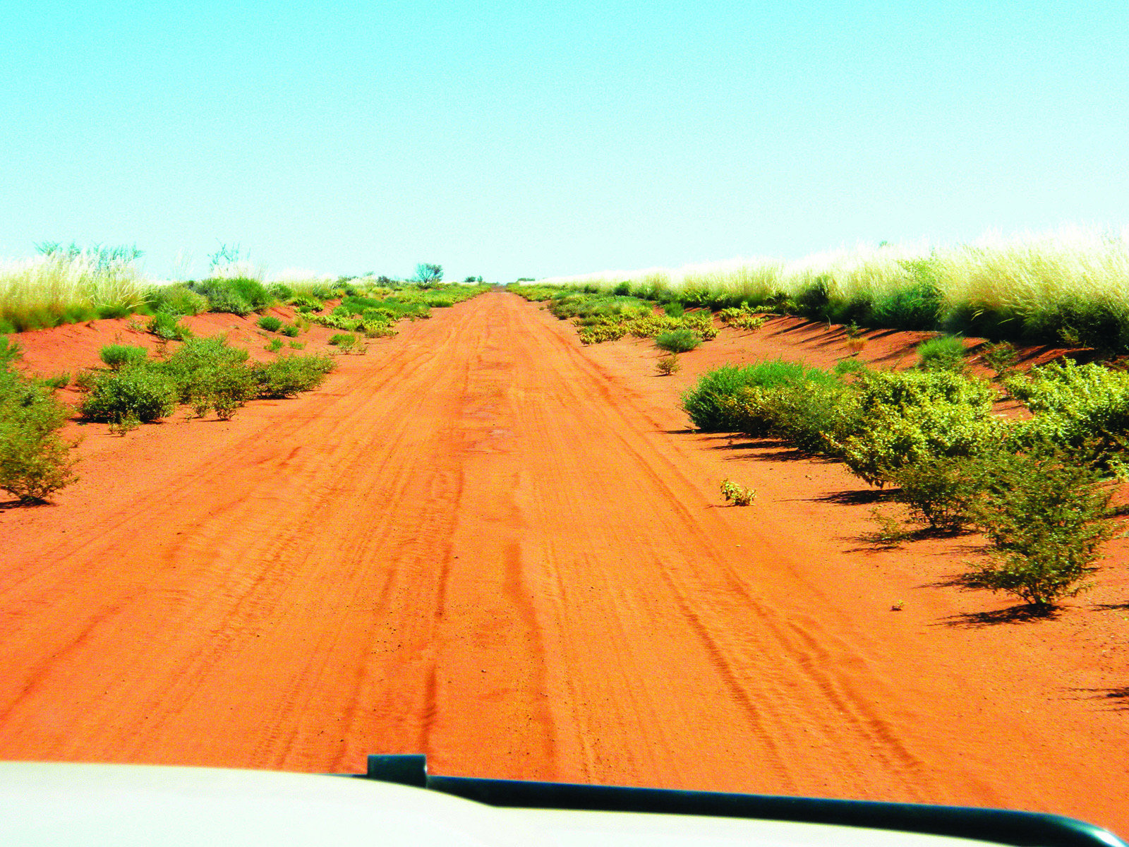
The journey is rated easy to moderate, suitable for high clearance vehicles and offroad-capable camper trailers and caravans. All roads mentioned are unsealed, except for bitumen sections west of Telfer Mine and the Rippon Hills Road.
The unsealed roads are generally wide and well formed, narrowing in places through the dunes. However, the nature and quality of their surface changes constantly, and drivers should be alert for some corrugations, occasional washouts, dry creek beds and soft sandy patches, which should be navigated with care.
Being so remote, the GJR and its extensions up to Telfer Mine receive little traffic, mostly supply trucks and the odd exploration survey vehicle. But around Telfer Mine and on the roads west of it you are likely to encounter many road trains hauling ore to Port Hedland.
Be prepared to give them a wide berth.
While solitude in the great outback has its benefits, remember that you are on your own and a long way from help if things go pear-shaped. Travellers in these remote and potentially hazardous regions need to be well-prepared, armed with a sat phone and/or EPIRB, and amply supplied in terms of food, fuel, and water.
FUEL AND SUPPLIES
Both diesel and Opal unleaded fuels are usually available at the Indigenous communities of Papunya, Mount Liebig, Kintore, Kiwirrkurra, Kunawarritji, and Punmu. Fuel is expensive and the further west you travel the higher the price. The bowsers often operate in conjunction with a general store, and these have unusual opening hours — sometimes they are not open as advertised — and it is advisable to check ahead to plan your fuel stops. Although Kiwirrkurra is in Western Australia, it runs on Northern Territory time. Most quality maps have contact numbers and opening times.
Basic supplies can be obtained at the community general stores. The range of stock is limited, and availability is dependent on the delivery truck, which usually comes once a week but can be delayed for several days. Credit cards may not be accepted everywhere and it’s a good idea to carry enough cash to cover your purchases.
There is no public access to Telfer Gold Mine, so don’t go there looking for fuel or supplies.
CAMPING
There are many bush camping opportunities along the journey through the Great Sandy Desert.
Buck Hills lie about 10km west of the West Australian border, north of the GJR. Between the road and the base of the nearest hill is an exposed site. From here, a track to the left runs clockwise around the hill to a number of camping spots nestled among the scenic hills.
Jupiter Well is a very pleasant camp, set off the north side of the road in a clearing amid large desert oaks. In the centre of the clearing stands a hand pump that dispenses clear, clean potable water. The serenity of the location is disturbed at dusk and dawn by flocks of galahs gathering at the water bucket beneath the pump!
The camping area at Carawine Gorge lies along the bank of the beautiful Oakover River and is accessed from Woodie Woodie Road by a 4WD track across Warrawagine Station with views of distant ranges. It is an excellent spot for swimming, fishing, and kayaking, and is full of birdlife. There are no fees to camp here, but a courtesy call to the station owners before visiting is appreciated.
FAST FACTS
CENTRAL LAND COUNCIL
27 Stuart Hwy, Alice Springs
P: (08) 8951 6211
W: clc.org.au
NGAANYATJARRA COUNCIL
Shop 6, 56-58 Head Street, Alice Springs
P: (08) 8950 1711 (transit permits)
P: (08) 8956 8658 (camping)
W: ngaanyatjarra.org.au
PAPUNYA COMMUNITY STORE
P: (08) 8956 8506
E: ppy@outbackstores.com.au
Mount Liebig Community Store
(08) 8956 8591
KINTORE COMMUNITY STORE
P: (08) 8956 8575
KIWIKURRA ROADHOUSE
P: (08) 8956 4935
E: kiwiroadhouse@bigpond.com
KUNAWARRITJI ROADHOUSE
P: (08) 9176 9040
E: kunawarritji@bigpond.com
PUNMU COMMUNITY
P: (08) 9176 9110
E: punmucorp@bigpond.com
WARRAWAGINE STATION (MILLS FAMILY)
P: (08) 9176 5900.
E: stationadmin@warrawagine.com.au


